Ground
require(["esri/Ground"], function(Ground) { /* code goes here */ });esri/GroundThe Ground class contains properties that specify how the ground surface is displayed in a SceneView. It contains a layers property, which is a collection of ElevationLayer that defines the elevation or terrain of the map's surface.
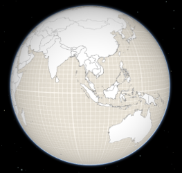
On a Map instance, a default ground surface using the World Elevation Service can conveniently be initialized through the ground property:
var map = new Map({
  basemap: "topo",
  ground: "world-elevation"
});
When terrain and bathymetry values are needed, the TopoBathy 3D Service can be used:
var map = new Map({
  basemap: "topo",
  ground: "world-topobathymetry"
});
When no basemap is available, the Ground displays a grid by default:
That can be changed by setting a color on the surfaceColor property:
map.ground.surfaceColor = '#004C73';

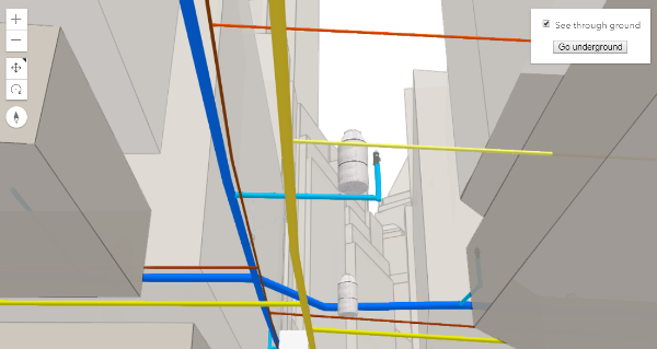
If the scene contains underground data, reduce the opacity of the ground to be able to see through the ground:
map.ground.opacity = 0.4;
Constructors
- new Ground(properties)
- Parameter:properties Objectoptional
See the properties for a list of all the properties that may be passed into the constructor.
Property Overview
| Name | Type | Summary | Class | |
|---|---|---|---|---|
| String | The name of the class. more details | more details | Accessor | |
| Collection<ElevationLayer> | A collection of ElevationLayers that define the elevation or terrain that makes up the ground surface. more details | more details | Ground | |
| Boolean | Indicates whether the instance has loaded. more details | more details | Ground | |
| Error | The Error object returned if an error occurred while loading. more details | more details | Ground | |
| String | Represents the status of a load operation. more details | more details | Ground | |
| Object[] | A list of warnings which occurred while loading. more details | more details | Ground | |
| Accessor | Specifies the user navigation constraints relative to the ground surface. more details | more details | Ground | |
| Number | Opacity of the ground, including surface default color and the basemap (without reference layers). more details | more details | Ground | |
| Color | The color of the ground surface, displayed underneath the basemap. more details | more details | Ground |
Property Details
- Since: ArcGIS API for JavaScript 4.7
The name of the class. The declared class name is formatted as
esri.folder.className.
- layersCollection<ElevationLayer>
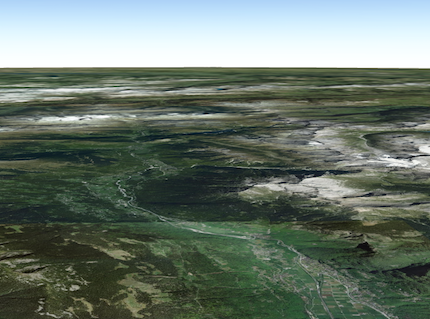
A collection of ElevationLayers that define the elevation or terrain that makes up the ground surface. When elevation layers are added to the ground, the topographical variations of the surface are rendered in 3D as they would appear in the real world.
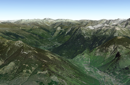
When the layers collection is empty, the ground surface is flat.
 Example:
// Adds the esri world elevation service to the ground
var layer = new ElevationLayer({
  url: "//elevation3d.arcgis.com/arcgis/rest/services/WorldElevation3D/Terrain3D/ImageServer"
});
map.ground.layers.add(layer);
- loadedBooleanreadonly
Indicates whether the instance has loaded. When
true, the properties of the object can be accessed. A Ground is considered loaded when its layers are fully created, but not yet loaded.- Default Value:false
- loadErrorErrorreadonly
The Error object returned if an error occurred while loading.
- Default Value:null
- loadStatusStringreadonly
Represents the status of a load operation.
Value Description not-loaded The object's resources have not loaded. loading The object's resources are currently loading. loaded The object's resources have loaded without errors. failed The object's resources failed to load. See loadError for more details. - Default Value:not-loaded
- loadWarningsObject[]readonly
A list of warnings which occurred while loading.
- Since: ArcGIS API for JavaScript 4.8
Specifies the user navigation constraints relative to the ground surface.
- Property:
- type String
The type of the constraint. It can be one of the following:
Value Description stay-above User can only navigate above ground surface none User can navigate above and below the ground surface Default value: stay-above
- opacityNumberSince: ArcGIS API for JavaScript 4.8
Opacity of the ground, including surface default color and the basemap (without reference layers). This property can be used for a see-through ground effect.
- Default Value:1
- Since: ArcGIS API for JavaScript 4.8
The color of the ground surface, displayed underneath the basemap. If this is null, a grid is displayed instead. The alpha value in the color is ignored. Use the opacity property to control the opacity of the ground.
- Default Value:null
Method Overview
| Name | Return Type | Summary | Class | |
|---|---|---|---|---|
Cancels a load() operation if it is already in progress. more details | more details | Ground | ||
| Ground | Creates a deep clone of this object. more details | more details | Ground | |
| Promise<ElevationSampler> | Creates an elevation sampler for the given extent by querying the ground layers for elevation data and caching it so values may be sampled quickly afterwards. more details | more details | Ground | |
| * | Creates a new instance of this class and initializes it with values from a JSON object generated from a product in the ArcGIS platform. more details | more details | Ground | |
| Boolean |
| more details | Ground | |
| Boolean |
| more details | Ground | |
| Boolean |
| more details | Ground | |
| Promise | Loads the resources referenced by this class. more details | more details | Ground | |
| Promise<Ground> | Loads all the externally loadable resources associated with the ground. more details | more details | Ground | |
| Promise<ElevationQueryResult> | Queries the ground layer services for elevation values for the given geometry. more details | more details | Ground | |
| Object | Converts an instance of this class to its ArcGIS portal JSON representation. more details | more details | Ground | |
| Promise |
| more details | Ground |
Method Details
- cancelLoad()
Cancels a load() operation if it is already in progress.
- clone(){Ground}
Creates a deep clone of this object.
Returns:Type Description Ground A deep clone of the Ground instance that invoked this method.
- createElevationSampler(extent, options){Promise<ElevationSampler>}Since: ArcGIS API for JavaScript 4.7
Creates an elevation sampler for the given extent by querying the ground layers for elevation data and caching it so values may be sampled quickly afterwards. The sampler uses the elevation data from the first layer that has data available. For getting elevation data from a specific layer use ElevationLayer.createElevationSampler().
Parameters:extent ExtentThe extent for which to create the sampler.
options ObjectoptionalAdditional sampler options.
Specification:noDataValue NumberoptionalDefault Value: 0The value to use when there is no data available.
Returns:Type Description Promise<ElevationSampler> An elevation sampler.
- fromJSON(json){*}static
Creates a new instance of this class and initializes it with values from a JSON object generated from a product in the ArcGIS platform. The object passed into the input
jsonparameter often comes from a response to a query operation in the REST API or a toJSON() method from another ArcGIS product. See the Using fromJSON() topic in the Guide for details and examples of when and how to use this function.Parameter:json ObjectA JSON representation of the instance in the ArcGIS format. See the ArcGIS REST API documentation for examples of the structure of various input JSON objects.
Returns:Type Description * Returns a new instance of this class.
- isFulfilled(){Boolean}
isFulfilled()may be used to verify if creating an instance of the class is fulfilled (either resolved or rejected). If it is fulfilled,truewill be returned.Returns:Type Description Boolean Indicates whether creating an instance of the class has been fulfilled (either resolved or rejected).
- isRejected(){Boolean}
isRejected()may be used to verify if creating an instance of the class is rejected. If it is rejected,truewill be returned.Returns:Type Description Boolean Indicates whether creating an instance of the class has been rejected.
- isResolved(){Boolean}
isResolved()may be used to verify if creating an instance of the class is resolved. If it is resolved,truewill be returned.Returns:Type Description Boolean Indicates whether creating an instance of the class has been resolved.
- load(){Promise}
Loads the resources referenced by this class. This method automatically executes for a View and all of the resources it references in Map if the view is constructed with a map instance.
This method must be called by the developer when accessing a resource that will not be loaded in a View.
Returns:Type Description Promise Resolves when the resources have loaded.
- Since: ArcGIS API for JavaScript 4.9
Loads all the externally loadable resources associated with the ground. For the ground this will load all the layers.
Returns:Type Description Promise<Ground> Resolves when all the loadable resources have been loaded. - See also:
- queryElevation(geometry, options){Promise<ElevationQueryResult>}
Queries the ground layer services for elevation values for the given geometry. The returned result contains a copy of the geometry with z-values sampled from elevation data from the first layer that has data available.
Parameters:geometry Point|Multipoint|PolylineThe geometry to sample.
options ObjectoptionalAdditional query options.
Specification:returnSampleInfo BooleanoptionalDefault Value: falseIndicates whether to return additional sample information for each sampled coordinate.
noDataValue NumberoptionalDefault Value: 0The value that appears in the resulting geometry when there is no data available.
Returns:Type Description Promise<ElevationQueryResult> Resolves to an object with the sampled geometry, resolution information, and no data value. Example:require(["esri/Map", "esri/geometry/Multipoint"], function(Map, Multipoint) { var map = new Map({ ground: "world-elevation" }); // Various points across a ridge of the mount everest var points = [ [ 86.9252, 27.9883 ], [ 86.9265, 27.9894 ], [ 86.9292, 27.9923 ], [ 86.9324, 27.9960 ], [ 86.9359, 27.9992 ] ]; map.ground.queryElevation(new Multipoint(points), { returnSampleInfo: true }) // Successfully sampled all points .then(function(result) { // Print result of each sampled point to the console result.geometry.points.forEach(function(point, index) { var elevation = Math.round(point[2]); var resolution = result.sampleInfo[index].demResolution; var coordinateText = "(" + point[0] + ", " + point[1] + ")"; var resolutionText = Math.round(resolution) + " meter resolution"; console.log("Sampled " + coordinateText + ": " + elevation + " at " + resolutionText); }); }) // Failed to sample (e.g. service unavailable) .catch(function(error) { console.error("Failed to query elevation:", error); }); });
- toJSON(){Object}
Converts an instance of this class to its ArcGIS portal JSON representation. See the Using fromJSON() topic in the Guide for more information.
Returns:Type Description Object The ArcGIS portal JSON representation of an instance of this class.
- when(callback, errback){Promise}Since: ArcGIS API for JavaScript 4.6
when()may be leveraged once an instance of the class is created. This method takes two input parameters: acallbackfunction and anerrbackfunction. Thecallbackexecutes when the instance of the class loads. Theerrbackexecutes if the instance of the class fails to load.Parameters:callback FunctionoptionalThe function to call when the promise resolves.
errback FunctionoptionalThe function to execute when the promise fails.
Returns:Type Description Promise Returns a new promise for the result of callbackthat may be used to chain additional functions.Example:// Although this example uses MapView, any class instance that is a promise may use then() in the same way var view = new MapView(); view.when(function(){ // This function will execute once the promise is resolved }, function(error){ // This function will execute if the promise is rejected due to an error });
Type Definitions
- ElevationQueryResult
Object returned when queryElevation() promise resolves:
- Properties:
- geometry Point | Multipoint | Polyline
The geometry with sampled z-values.
optionalsampleInfo Object[]Contains additional information about how the geometry was sampled. This property is present depending on whether the user set
options.returnSampleInfo = true, for each coordinate in the geometry.- Specification:
- demResolution Number
The resolution at which the z-value was sampled. If no data was available for sampling for a given coordinate, the dem resolution value will be -1 for that coordinate.
source ElevationLayerThe elevation source from which the data for the corresponding coordinate was sampled.
noDataValue NumberThe value used when there is no data available.