Edges3D
require(["esri/symbols/edges/Edges3D"], function(Edges3D) { /* code goes here */ });esri/symbols/edges/Edges3DEdges3D is the base class for symbol classes that add edge rendering visualization to existing symbols. Edge rendering visualization is specific for 3D visualizations and can only be applied to FillSymbol3DLayer on MeshSymbol3D or ExtrudeSymbol3DLayer on PolygonSymbol3D.
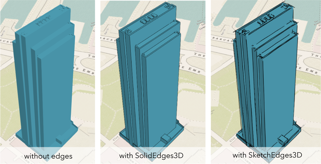
Currently only edges of type solid and sketch are supported. See SolidEdges3D and SketchEdges3D.
Constructors
- new Edges3D(properties)
- Parameter:properties Objectoptional
See the properties for a list of all the properties that may be passed into the constructor.
Property Overview
| Name | Type | Summary | Class | |
|---|---|---|---|---|
| Color | The color of the edges. more details | more details | Edges3D | |
| String | The name of the class. more details | more details | Accessor | |
| Number | A size in points by which to extend edges beyond their original end points. more details | more details | Edges3D | |
| Number | The size of the edges in points. more details | more details | Edges3D |
Property Details
The color of the edges. This can be autocast with a named string, hex string, array of rgb or rgba values, an object with
r,g,b, andaproperties, or a Color object.- Default Value:black
- Since: ArcGIS API for JavaScript 4.7
The name of the class. The declared class name is formatted as
esri.folder.className.
- Autocasts from String
A size in points by which to extend edges beyond their original end points.
- Default Value:"0"
- Autocasts from String
The size of the edges in points. This value may be autocast with a string expressing size in points or pixels (e.g.
12px).- Default Value:1px
Method Overview
| Name | Return Type | Summary | Class | |
|---|---|---|---|---|
| Edges3D | Creates a deep clone of the edges. more details | more details | Edges3D | |
| * | Creates a new instance of this class and initializes it with values from a JSON object generated from a product in the ArcGIS platform. more details | more details | Edges3D | |
| Object | Converts an instance of this class to its ArcGIS portal JSON representation. more details | more details | Edges3D |
Method Details
- clone(){Edges3D}
Creates a deep clone of the edges.
Returns:Type Description Edges3D A deep clone of the object that invoked this method.
- fromJSON(json){*}static
Creates a new instance of this class and initializes it with values from a JSON object generated from a product in the ArcGIS platform. The object passed into the input
jsonparameter often comes from a response to a query operation in the REST API or a toJSON() method from another ArcGIS product. See the Using fromJSON() topic in the Guide for details and examples of when and how to use this function.Parameter:json ObjectA JSON representation of the instance in the ArcGIS format. See the ArcGIS REST API documentation for examples of the structure of various input JSON objects.
Returns:Type Description * Returns a new instance of this class.
- toJSON(){Object}
Converts an instance of this class to its ArcGIS portal JSON representation. See the Using fromJSON() topic in the Guide for more information.
Returns:Type Description Object The ArcGIS portal JSON representation of an instance of this class.