MapView
require(["esri/views/MapView"], function(MapView) { /* code goes here */ });esri/views/MapView- Overview
- Using the view
- Programmatic navigation
- MapView navigation
- MapView navigation with Gamepad and 3DConnexion Devices
Overview
A MapView displays a 2D view of a Map instance. An instance of MapView must be created to render a Map (along with its operational and base layers) in 2D. To render a map and its layers in 3D, see the documentation for SceneView. For a general overview of views, see View.
For a map to be visible to the user in the DOM, a MapView must be created and reference a minimum of two objects: a Map instance and a DOM element. Each is set in the map and container properties respectively.
// Create a MapView instance (for 2D viewing)
var view = new MapView({
  map: myMap,  // References a Map instance
  container: "viewDiv"  // References the ID of a DOM element
});
Using the view
In addition to being responsible for the rendering of the Map and its elements, the MapView handles the interaction between the user and the map. For example, the traditional map scale isn't set on the Map; it's set on the MapView.
view.scale = 24000; // Sets a 1:24,0000 scale on the view
You can set the initial extent (or visible portion of the map) by using either a combination of center and zoom, or by setting the extent property.
// Set the center and zoom level on the view
view.center = [-112, 38];  // Sets the center point of the view at a specified lon/lat
view.zoom = 13;  // Sets the zoom LOD to 13
// Set the extent on the view
view.extent = new Extent({
  xmin: -9177882,
  ymin: 4246761,
  xmax: -9176720,
  ymax: 4247967,
  spatialReference: {
    wkid: 102100
  }
});
.when() method on the MapView instance can be called to execute processes that may only run after the map has loaded.
// Create a MapView instance (for 2D viewing)
var view = new MapView({
  map: myMap,  // References a Map instance
  container: "viewDiv"  // References the ID of a DOM element
});

view.when(function(){
 // All the resources in the MapView and the map have loaded. Now execute additional processes
}, function(error){
 // Use the errback function to handle when the view doesn't load properly
 console.log("The view's resources failed to load: ", error);
});
For live examples of view.when(), see the how to Add 2D overview map in SceneView samples.
Programmatic navigation
Because some view properties override one another (e.g. scale and extent), there is a set priority in which these properties are applied during construction of the view (until the view becomes ready). The following table describes which properties have priority during view construction (properties that are overridden will have no effect during construction).
| Property | Overrides |
|---|---|
| viewpoint | extent, center, scale, zoom |
| extent | center, scale, zoom |
| scale | zoom |
Because the View handles user interaction, events such as click are handled on the MapView. Animations are also possible with the goTo() method, which allows you to change or move the MapView from one extent to another.
MapView navigation
MapView navigation is enabled by default and includes mouse interaction as described in the table below.
| Action | MapView behavior |
|---|---|
| Drag | Pan |
| Double-click | Zoom in at the cursor |
| Shift+Double-click | Zoom out at the cursor |
| Scroll forward | Zoom in at the cursor |
| Scroll backward | Zoom out at the cursor |
| Right-click+Drag | 2D-rotate |
| Shift+Left-click+Drag | Zoom to extent of drawn graphic |
| Arrow Keys | Nudge the view to left, right, up or down |
| N | Adjust the view to point north |
| A | Rotate the view counterclockwise |
| D | Rotate the view clockwise |
| + | Incrementally zoom in at the center of the map |
| - | Incrementally zoom out at the center of the map |
To disable MapView navigation, you must call the stopPropagation() method on the event objects of the pointer or gesture events that trigger the navigation.
See our samples on disabling view navigation for examples.
MapView navigation with Gamepad and 3DConnexion devices
Gamepads and 3Dconnexion devices, like the SpaceMouse, can be used for navigation when view.navigation.gamepad.enabled is set to true(default). Please see GamepadInputDevice for supported devices.
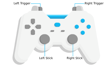
| Gamepad Action | MapView behavior |
|---|---|
| Left Trigger | Zoom in |
| Right Trigger | Zoom out |
| Left Stick | Pan the view |
| Right Stick | Rotate the view |
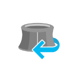
| Action Image | SpaceMouse Action | MapView behavior |
|---|---|---|
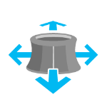 | Push (left/right/forward/backward) | Pan the view |
 | Pull up | Zoom out |
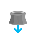 | Push down | Zoom in |
 | Rotate clockwise | Rotate the view clockwise |
 | Rotate counterclockwise | Rotate the view counterclockwise |
To disable gamepad navigation, you can set view.navigation.gamepad.enabled to false.
Note: zoom snapping must be disabled for continuous zooming.
view.constraints.snapToZoom = false;
- See also:
Constructors
- new MapView(properties)
- Parameter:properties Objectoptional
See the properties for a list of all the properties that may be passed into the constructor.
Example:// Typical usage var view = new MapView({ // ID of DOM element containing the view container: "viewDiv", // Map/WebMap object map: new Map() });
Property Overview
| Name | Type | Summary | Class | |
|---|---|---|---|---|
| Collection<LayerView> | Collection containing a flat list of all the created LayerViews related to the basemap, operational layers, and group layers in this view. more details | more details | View | |
| ViewAnimation | Represents an ongoing view animation initialized by goTo(). more details | more details | MapView | |
| Object | A convenience property used for defining the breakpoints on the height and width of the view. more details | more details | MapView | |
| Point | Represents the view's center point; when setting the center, you may pass a Point instance or an array of numbers representing a longitude/latitude pair ( | more details | MapView | |
| Object | Specifies constraints to scale, zoom, and rotation that may be applied to the MapView. more details | more details | MapView | |
| HTMLDivElement | The | more details | View | |
| String | The name of the class. more details | more details | Accessor | |
| Extent | The extent represents the visible portion of a map within the view as an instance of Extent. more details | more details | MapView | |
| Boolean | Indicates if the browser focus is on the view. more details | more details | View | |
| Collection<Graphic> | Allows for adding graphics directly to the default graphics in the View. more details | more details | View | |
| GroundView | The view for the ground of the map. more details | more details | View | |
| Number | The height of the view in pixels read from the view container element. more details | more details | View | |
| String | A convenience property indicating the general size of the view's height. more details | more details | MapView | |
| Object | Options for configuring the highlight. more details | more details | MapView | |
| Input | Options to configure input handling of the View. more details | more details | View | |
| Boolean | Indication whether the view is being interacted with (for example when panning). more details | more details | View | |
| Collection<LayerView> | A collection containing a hierarchical list of all the created LayerViews of the operational layers in the map. more details | more details | View | |
| Map | An instance of a Map object to display in the view. more details | more details | View | |
| Navigation | Options to configure the navigation behavior of the View. more details | more details | View | |
| String | A convenience property indicating the view's orientation. more details | more details | MapView | |
| Object | Use the padding property to make the center, and extent, etc. more details | more details | View | |
| Popup | A Popup object that displays general content or attributes from layers in the map. more details | more details | View | |
| Boolean | When | more details | View | |
| String | Defines which anchor stays still while resizing the browser window. more details | more details | MapView | |
| Boolean | Indicates if the view is being resized. more details | more details | View | |
| Number | Represents the size of one pixel in map units. more details | more details | MapView | |
| Number | The clockwise rotation of due north in relation to the top of the view in degrees. more details | more details | MapView | |
| Number | Represents the map scale at the center of the view. more details | more details | MapView | |
| Number[] | An array containing the width and height of the view in pixels, e.g. more details | more details | View | |
| SpatialReference | The spatial reference of the view. more details | more details | View | |
| Boolean | Indication whether the view is animating, being interacted with or resizing. more details | more details | View | |
| Boolean | Indicates if the view is visible on the page. more details | more details | View | |
| String | The dimension of the view. more details | more details | MapView | |
| DefaultUI | Exposes the default widgets available in the view and allows you to toggle them on and off. more details | more details | View | |
| Boolean | Indicates whether the view is being updated by additional data requests to the network, or by processing received data. more details | more details | View | |
| Viewpoint | Represents the current view as a Viewpoint or point of observation on the view. more details | more details | MapView | |
| Number | The width of the view in pixels read from the view container element. more details | more details | View | |
| String | A convenience property indicating the general size of the view's width. more details | more details | MapView | |
| Number | Represents the level of detail (LOD) at the center of the view. more details | more details | MapView |
Property Details
- allLayerViewsCollection<LayerView> inherited
Collection containing a flat list of all the created LayerViews related to the basemap, operational layers, and group layers in this view.
- See also:
- animationViewAnimation
Represents an ongoing view animation initialized by goTo(). You may watch this property to be notified of the animation's state.
- See also:
Example:view.watch("animation", function(response){ if(response && response.state === "running"){ console.log("Animation in progress"); } else{ console.log("No animation"); } });
- breakpointsObject
A convenience property used for defining the breakpoints on the height and width of the view. The sizes specified here determine the values of the widthBreakpoint and heightBreakpoint properties depending on the view's size.
Setting up breakpoints can aid in responsive app design. It does this by watching width and height breakpoints. This is helpful as it removes the need for multiple
@mediacalls. Instead of listening for the view's size and/or resizes property, you can set up a watch handler for either the widthBreakpoint or heightBreakpoint properties of the view.Please refer to the styling guide for additional information on working with this.
- Properties:
- optionalxsmall NumberDefault Value:544
Sets the
xsmallbreakpoint in pixels used by widthBreakpoint and heightBreakpoint. If the view's height or width is smaller than this value, then the value of widthBreakpoint or heightBreakpoint will bexsmall.optionalsmall NumberDefault Value:768Sets the
smallbreakpoint in pixels used by widthBreakpoint and heightBreakpoint. If the view's height or width is between this value and the value of thexsmallproperty, then the value of widthBreakpoint or heightBreakpoint will besmall.optionalmedium NumberDefault Value:992Sets the
mediumbreakpoint in pixels used by widthBreakpoint and heightBreakpoint. If the view's height or width is between this value and the value of thesmallproperty, then the value of widthBreakpoint or heightBreakpoint will bemedium.optionallarge NumberDefault Value:1200Sets the
largebreakpoint in pixels used by widthBreakpoint and heightBreakpoint. If the view's height or width is between this value and the value of themediumproperty, then the value of widthBreakpoint or heightBreakpoint will belarge.optionalxlarge NumberSets the
xlargebreakpoint in pixels used by widthBreakpoint and heightBreakpoint. If the view's height or width is greater than the value of thelargeproperty, then the value of widthBreakpoint or heightBreakpoint will bexlarge. - See also:
Example:// Instead of watching the size or resizing properties view.watch(size) view.watch(resizing) // Set up a watch handle for breakpoint view.watch("widthBreakpoint",function(breakpoint){ switch (breakpoint) { case "xsmall": // do something break; case "small": case "medium": case "large": case "xlarge": // do something else break; default: } });
Represents the view's center point; when setting the center, you may pass a Point instance or an array of numbers representing a longitude/latitude pair (
[-100.4593, 36.9014]). Setting the center immediately changes the current view. For animating the view, see goTo().If set in the constructor, this property will be ignored if the viewpoint or extent properties are also set in the constructor.
The returned Point object is always in the spatial reference of the map and may be modified internally. To persist the returned object, create a clone using Point.clone().
- See also:
Examples:// Sets the initial center point of the view to lon/lat coordinates var view = new MapView({ center: [-112, 38] });// Updates the view's center point to a pre-determined Point object var pt = new Point({ x: 12804.24, y: -1894032.09, spatialReference: 2027 }); view.center = pt;
- constraintsObject
Specifies constraints to scale, zoom, and rotation that may be applied to the MapView. See object specification below.
- Properties:
- optionallods LOD[]
An array of LODs. If not specified, this value is read from the Map. This property may be autocast.
optionalminScale NumberThe minimum scale the user is allowed to zoom to within the view.
optionalmaxScale NumberThe maximum scale the user is allowed to zoom to within the view. Setting this value to
0allows the user to overzoom layer tiles.optionalminZoom NumberThe minimum zoom level the user is allowed to zoom to within the view.
optionalmaxZoom NumberThe maximum zoom level the user is allowed to zoom to within the view. Setting this value to
0allows the user to overzoom layer tiles.optionalsnapToZoom BooleanDefault Value:trueWhen
true, the view snaps to the next LOD when zooming in or out. Whenfalse, the zoom is continuous.optionalrotationEnabled BooleanDefault Value:trueIndicates whether the user can rotate the map.
optionaleffectiveLODs LOD[]A read-only property that specifies the levels of detail (LODs) read from the Map.
optionaleffectiveMinZoom NumberA read-only property that specifies the minimum zoom level the user is allowed to zoom to within the view.
optionaleffectiveMaxZoom NumberA read-only property that specifies the maximum zoom level the user is allowed to zoom to within the view.
optionaleffectiveMinScale NumberA read-only property that specifies the minimum scale the user is allowed to zoom to within the view.
optionaleffectiveMaxScale NumberA read-only property that specifies the maximum scale the user is allowed to zoom to within the view.
Example:view.constraints = { minScale: 500000, // User cannot zoom out beyond a scale of 1:500,000 maxScale: 0, // User can overzoom tiles rotationEnabled: false // Disables map rotation };
- Autocasts from String
The
idor node representing the DOM element containing the view. This is typically set in the view's constructor.Examples:// Sets container to the DOM id var view = new MapView({ container: "viewDiv" // ID of the HTML element that holds the view });// Sets container to the node var viewNode = document.getElementById("viewDiv"); var view = new SceneView({ container: viewNode });
- Since: ArcGIS API for JavaScript 4.7
The name of the class. The declared class name is formatted as
esri.folder.className.
The extent represents the visible portion of a map within the view as an instance of Extent. Setting the extent immediately changes the view without animation. To animate the view, see goTo().
The returned Extent object is an internal reference which may be modified internally. To persist the returned object, create a copy using Extent.clone().
- Default Value:null
- See also:
Example:var ext = new Extent({ xmin: -13056650, ymin: 6077558, xmax: -13055709, ymax: 6077938, spatialReference: new SpatialReference({wkid:3857}) }); view.extent = ext; // Updates the view without animation
- Since: ArcGIS API for JavaScript 4.7
Indicates if the browser focus is on the view.
- graphicsCollection<Graphic> inherited
Allows for adding graphics directly to the default graphics in the View.
Examples:// Adds a graphic to the View view.graphics.add(pointGraphic);// Removes a graphic from the View view.graphics.remove(pointGraphic);
- Since: ArcGIS API for JavaScript 4.7
The view for the ground of the map.
The height of the view in pixels read from the view container element.
The view container needs to have a height greater than 0 to be displayed.
- Default Value:0
- heightBreakpointString
A convenience property indicating the general size of the view's height. This value is determined based on where the view's height falls in the ranges defined in the breakpoints property. See the table below for a list of possible values. Use the breakpoints property to override the default thresholds.
Please refer to the styling guide for additional information on working with this.
Possible Value Description Default thresholds (pixels) xsmall The height of the view is smaller than the value set in the xsmallbreakpoint.< 545 small The height of the view is between the values set in the xsmallandsmallbreakpoints.545 - 768 medium The height of the view is between the values set in the smallandmediumbreakpoints.769 - 992 large The height of the view is between the values set in the mediumandlargebreakpoints.993 - 1200 xlarge The height of the view is larger than the value set in the largebreakpoint.> 1200 Example:view.watch("heightBreakpoint", function(newVal){ if (newVal === "xsmall"){ // clear the view's default UI components if // app is used on a mobile device view.ui.components = []; } });
- Since: ArcGIS API for JavaScript 4.5
Options for configuring the highlight. Use the highlight method on the appropriate LayerView to highlight a feature.
- Properties:
- optionalcolor ColorDefault Value:#00ffff
The color of the highlight.
optionalhaloOpacity NumberDefault Value:1The opacity of the highlight halo. This will be multiplied with the opacity specified in
color.optionalfillOpacity NumberDefault Value:0.25The opacity of the fill (area within the halo). This will be multiplied with the opacity specified in
color. - See also:
Example:var view = new MapView({ map: map, highlightOptions: { color: [255, 255, 0, 1], haloOpacity: 0.9, fillOpacity: 0.2 } });
- Since: ArcGIS API for JavaScript 4.9
Options to configure input handling of the View.
Example:// Make gamepad events to emit independently of focus. view.input.gamepad.enabledFocusMode = "none";
Indication whether the view is being interacted with (for example when panning).
- Default Value:false
- layerViewsCollection<LayerView> inherited
A collection containing a hierarchical list of all the created LayerViews of the operational layers in the map.
- See also:
An instance of a Map object to display in the view. A view may only display one map at a time. On the other hand, one Map may be viewed by multiple MapViews and/or SceneViews simultaneously.
This property is typically set in the constructor of the MapView or SceneView. See the class description for examples demonstrating the relationship between the map and the view.
- orientationStringreadonly
A convenience property indicating the view's orientation. See the table below for a list of possible values.
Please refer to the styling guide for additional information on working with this.
Possible Value Description landscape The width of the view is greater than its height. portrait The width of the view is equal to or smaller than its height.
Use the padding property to make the center, and extent, etc. work off a subsection of the full view. This is particularly useful when layering UI elements or semi-transparent content on top of portions of the view. See the view padding sample for an example of how this works.
A Popup object that displays general content or attributes from layers in the map.
The view has a default instance of Popup with predefined styles and a template for defining content. The content in this default instance may be modified directly in the popup's content or in a layer's PopupTemplate.
You may create a new Popup instance and set it to this property to customize the style, positioning, and content of the popup in favor of using the default popup instance on the view.
In addition, if wanting to prevent any popups from opening, use the syntax below:
Example:view.popup = null;
When
true, this property indicates whether the view successfully satisfied all dependencies, signaling that the following conditions are met.- The view has a map. If map is a WebMap or a WebScene, then the map or scene must be loaded.
- The view has a container with a size greater than
0. - The view has a spatialReference.
When a view becomes ready it will resolve itself and invoke the callback defined in when() where code can execute on a working view. Subsequent changes to a view's readiness would typically be handled by watching
view.readyand providing logic for cases where the map or container change.- Default Value:false
- See also:
- resizeAlignString
Defines which anchor stays still while resizing the browser window. The default,
center, ensures the view's center point remains constantly visible as the window size changes. The other options allow the respective portion of the view to remain visible when the window's size is changed.Possible values: center | left | right | top | bottom | top-left | top-right | bottom-left | bottom-right
- Default Value:center
Indicates if the view is being resized.
- Default Value:false
- resolutionNumberreadonlySince: ArcGIS API for JavaScript 4.9
Represents the size of one pixel in map units. The value of resolution can be found by dividing the extent width by the view's width.
- rotationNumber
The clockwise rotation of due north in relation to the top of the view in degrees. The view may be rotated by directly setting the rotation or by using the following mouse event:
Right-click + Drag. Map rotation may be disabled by setting therotationEnabledproperty in constraints tofalse. See the code snippet below for an example of this.- Default Value:0
Examples:// Due north is rotated 90 degrees, pointing to the right side of the view view.rotation = 90;// Due north is rotated 180 degrees, pointing to the bottom of the view view.rotation = 180;// Due north is rotated 270 degrees, pointing to the left side of the view view.rotation = 270;// Due north is rotated 0 degrees, pointing to the top of the view (the default) view.rotation = 0; // 360 or multiple of 360 (e.g. 720) works here as well.// Disables map rotation view.constraints = { rotationEnabled: false };
- scaleNumber
Represents the map scale at the center of the view. Setting the scale immediately changes the view. For animating the view, see goTo().
- See also:
Example:view.scale = 24000; // Sets the map scale in the view's center to 1:24,000
An array containing the width and height of the view in pixels, e.g.
[width, height].
The spatial reference of the view. This indicates the Projected Coordinate System or the Geographic Coordinate System used to locate geographic features in the map. In a SceneView the following supported coordinate systems are available.
The spatial reference can either be set explicitly or automatically derived from the following:
- In the case of a SceneView, if the map is a WebScene instance, the WebScene.initialViewProperties.spatialReference is used.
- In all other cases, the spatial reference is derived from the first layer that loads in this order:
When using an Esri basemap, the default spatial reference is Web Mercator Auxiliary Sphere.
- Default Value:null
Indication whether the view is animating, being interacted with or resizing.
- Default Value:true
Indicates if the view is visible on the page. Is
trueif the view has no container, a height or width equal to 0, or the CSSvisibilityishidden.- Default Value:true
- typeStringreadonly
The dimension of the view. For MapView, this value is always
2d.
Exposes the default widgets available in the view and allows you to toggle them on and off. See DefaultUI for more details.
Examples:var toggle = new BasemapToggle({ view: view, nextBasemap: "hybrid" }); // Adds an instance of BasemapToggle widget to the // top right of the view. view.ui.add(toggle, "top-right");// Moves the zoom and BasemapToggle widgets to the // bottom left of the view. view.ui.move([ "zoom", toggle ], "bottom-left");// Removes all the widgets from the bottom left of the view view.ui.empty("bottom-left");// Removes the compass widget from the view view.ui.remove("compass");
Indicates whether the view is being updated by additional data requests to the network, or by processing received data.
- Default Value:false
- viewpointViewpoint
Represents the current view as a Viewpoint or point of observation on the view. Setting the viewpoint immediately changes the current view. For animating the view, see goTo().
The returned Viewpoint object is an internal reference which may be modified internally. To persist the returned object, create a copy using Viewpoint.clone().
- See also:
The width of the view in pixels read from the view container element.
The view container needs to have a width greater than 0 to be displayed.
- Default Value:0
- widthBreakpointString
A convenience property indicating the general size of the view's width. This value is determined based on where the view's width falls in the ranges defined in the breakpoints property. See the table below for a list of possible values. Use the breakpoints property to override the default thresholds.
Please refer to the styling guide for additional information on working with this.
Possible Value Description Default thresholds (pixels) xsmall The width of the view is smaller than the value set in the xsmallbreakpoint.< 545 small The width of the view is between the values set in the xsmallandsmallbreakpoints.545 - 768 medium The width of the view is between the values set in the smallandmediumbreakpoints.769 - 992 large The width of the view is between the values set in the mediumandlargebreakpoints.993 - 1200 xlarge The width of the view is larger than the value set in the largebreakpoint.> 1200 Example:view.watch("widthBreakpoint", function(newVal){ if (newVal === "xsmall"){ // clear the view's default UI components if // app is used on a mobile device view.ui.components = []; } });
- zoomNumber
Represents the level of detail (LOD) at the center of the view. Setting the zoom immediately changes the current view. For animating the view, see goTo().
Setting this property in conjunction with center is a convenient way to set the initial extent of the view.
- See also:
Examples:view.zoom = 3; // Sets the LOD to 3 (small map scale) view.zoom = 18; // Sets the LOD to 18 (large map scale)// Set the zoom level and center in the constructor var view = new MapView({ zoom: 10, center: [-120, 34], map: map });
Method Overview
| Name | Return Type | Summary | Class | |
|---|---|---|---|---|
Sets the focus on the view. more details | more details | View | ||
| Promise | Sets the view to a given target. more details | more details | MapView | |
Indicates whether there is an event listener on the instance that matches the provided event name. more details | more details | MapView | ||
| Promise<HitTestResult> | Returns the topmost feature from each layer that intersects the specified screen coordinates. more details | more details | MapView | |
| Boolean |
| more details | View | |
| Boolean |
| more details | View | |
| Boolean |
| more details | View | |
| Object | Registers an event handler on the instance. more details | more details | View | |
| Point | Converts the given screen point to a map point. more details | more details | MapView | |
| ScreenPoint | Converts the given map point to a screen point. more details | more details | MapView | |
| Promise |
| more details | View | |
| Promise<LayerView> | Gets the LayerView created on the view for the given layer. more details | more details | View |
Method Details
- focus()inheritedSince: ArcGIS API for JavaScript 4.5
Sets the focus on the view.
- goTo(target, options){Promise}
Sets the view to a given target. The target parameter can be one of the following:
[longitude, latitude]pair of coordinates- Geometry (or array of Geometry[])
- Graphic (or array of Graphic[])
- Viewpoint
- Object with a combination of
target,centerandscaleproperties (withtargetbeing any of the types listed above). Thecenterproperty is provided as a convenience to animate the MapView.center and is equivalent to specifying thetargetwith the center Point.
This function returns a promise which resolves as soon as the new view has been set to the target. If the transition is animated, then the ongoing animation can be obtained using MapView.animation.
If a tiled map service is used as the basemap and
snapToZoomproperty is set totruein constraints, thegoTomethod will zoom to the level of detail (LOD) of the basemap that is nearest to the definedtarget. IfsnapToZoomproperty is set tofalse, thegoTomethod will zoom to the exacttarget.Parameters:The target location/viewpoint to animate to. When using an object for
target, use the properties in the table below.Specification:optional The target of the animation.
center Number[]optionalThe MapView.center to go to.
scale NumberoptionalThe MapView.scale to go to.
zoom NumberoptionalThe MapView.zoom to go to.
options ObjectoptionalAnimation options. See properties below for object specifications.
Specification:animate BooleanoptionalDefault Value: trueIndicates if the transition to the new view should be animated. If set to false,
durationandeasingproperties are ignored.duration NumberoptionalDefault Value: 200The duration of the animation in milliseconds.
optional Default Value: easeThe easing function used for the animation. See easing functions for graphical representations of these functions.
Possible Values: linear | ease | ease-in | ease-out | ease-in-out
Returns:Type Description Promise A promise which resolves when the view is set to the target. Examples:var pt = new Point({ latitude: 49, longitude: -126 }); // go to the given point view.goTo(pt);var opts = { duration: 5000 // Duration of animation will be 5 seconds }; // go to point at LOD 15 with custom duration view.goTo({ target: pt, zoom: 15 }, opts);// go to same point using center and zoom view.goTo({ center: [-126, 49], zoom: 15 });
- hasEventListener()
Indicates whether there is an event listener on the instance that matches the provided event name.
- hitTest(screenPoint){Promise<HitTestResult>}
Returns the topmost feature from each layer that intersects the specified screen coordinates. The following layer types will return a result if a hit is made on an intersecting feature: GraphicsLayer, FeatureLayer, CSVLayer, GeoRSSLayer, KMLLayer, and StreamLayer.
At 4.6 and later, a hit test will always return a result from VectorTileLayer. However, the result will only indicate the ID and the name of the layer within the vector tile style that intersects the screen point. Detailed attribute and spatial information about the actual feature represented in the layer is not returned. HitTest results returned from VectorTileLayers are primarily used for Vector tile style editor applications.
Parameters:screenPoint ObjectThe screen coordinates of the click on the view.
Specification:x NumberThe horizontal screen coordinate of the click on the view.
y NumberThe vertical screen coordinate of the click on the view.
Returns:Type Description Promise<HitTestResult> When resolved, returns an object containing the graphics (if present) that intersect the given screen coordinates. Example:// Get the screen point from the view's click event view.on("click", function (event) { var screenPoint = { x: event.x, y: event.y }; // Search for graphics at the clicked location view.hitTest(screenPoint).then(function (response) { if (response.results.length) { var graphic = response.results.filter(function (result) { // check if the graphic belongs to the layer of interest return result.graphic.layer === myLayer; })[0].graphic; // do something with the result graphic console.log(graphic.attributes); } }); });
isFulfilled()may be used to verify if creating an instance of the class is fulfilled (either resolved or rejected). If it is fulfilled,truewill be returned.Returns:Type Description Boolean Indicates whether creating an instance of the class has been fulfilled (either resolved or rejected).
isRejected()may be used to verify if creating an instance of the class is rejected. If it is rejected,truewill be returned.Returns:Type Description Boolean Indicates whether creating an instance of the class has been rejected.
isResolved()may be used to verify if creating an instance of the class is resolved. If it is resolved,truewill be returned.Returns:Type Description Boolean Indicates whether creating an instance of the class has been resolved.
Registers an event handler on the instance. Call this method to hook an event with a listener. See the Events summary table for a list of listened events.
Parameters:The name of the event or events to listen for.
Additional modifier keys to filter events. Please see Key Values for possible values. All the standard key values are supported. Alternatively, if no modifiers are required, the function will call when the event fires.
The following events don't support modifier keys:
blur,focus,layerview-create,layerview-destroy,resize.handler FunctionoptionalThe function to call when the event is fired, if modifiers were specified.
Returns:Type Description Object Returns an event handler with a remove()method that can be called to stop listening for the event.Property Type Description remove Function When called, removes the listener from the event. - See also:
Example:view.on("click", function(event){ // event is the event handle returned after the event fires. console.log(event.mapPoint); }); // Fires `pointer-move` event when user clicks on "Shift" // key and moves the pointer on the view. view.on('pointer-move', ["Shift"], function(evt){ var point = view2d.toMap({x: evt.x, y: evt.y}); bufferPoint(point); });
- toMap(screenPoint){Point}
Converts the given screen point to a map point.
Parameters:screenPoint ObjectThe screen coordinates to convert.
Specification:x NumberThe horizontal screen coordinate to convert.
y NumberThe vertical screen coordinate to convert.
Returns:Type Description Point The map point corresponding to the given screen point.
- toScreen(point, screenPoint){ScreenPoint}
Converts the given map point to a screen point.
Parameters:point PointA point geometry.
screenPoint ScreenPointoptionalScreenPoint object that will reference the result.
Returns:Type Description ScreenPoint The screen point corresponding to the given map point.
- Since: ArcGIS API for JavaScript 4.6
when()may be leveraged once an instance of the class is created. This method takes two input parameters: acallbackfunction and anerrbackfunction. Thecallbackexecutes when the instance of the class loads. Theerrbackexecutes if the instance of the class fails to load.Parameters:callback FunctionoptionalThe function to call when the promise resolves.
errback FunctionoptionalThe function to execute when the promise fails.
Returns:Type Description Promise Returns a new promise for the result of callbackthat may be used to chain additional functions.Example:// Although this example uses MapView, any class instance that is a promise may use then() in the same way var view = new MapView(); view.when(function(){ // This function will execute once the promise is resolved }, function(error){ // This function will execute if the promise is rejected due to an error });
Gets the LayerView created on the view for the given layer. The returned promise resolves when the layer view for the given layer has been created, or rejects with an error (for example if the layer is not part of the view, or if the layer type is not supported in this view).
Parameter:layer LayerThe layer for which to obtain its LayerView.
Returns:Type Description Promise<LayerView> Resolves to an instance of LayerView for the specified layer. - See also:
Example:// Create a feature layer from a url pointing to a Feature Service var layer = new FeatureLayer(url); map.add(layer); view.whenLayerView(layer) .then(function(layerView) { // The layerview for the layer }) .catch(function(error) { // An error occurred during the layerview creation });
Type Definitions
- HitTestResult
Object specification for the result of the hitTest() method.
- Properties:
- results Object[]
An array of result objects returned from the hitTest(). Results are returned when the location of the input screen coordinates intersect a Graphic in the view. See the table below for the specification of each object in this array.
- Specification:
- graphic Graphic
A graphic representing a feature in the view that intersects the input screen coordinates. If the graphic comes from a layer with an applied Renderer, then the symbol property will be empty. Other properties may be empty based on the context in which the graphic is fetched.
If the result comes from a VectorTileLayer then a static graphic is returned with two
attributes:layerIdandlayerName. These correspond to the name and id of the style-layer in the vector tile style.mapPoint PointThe point geometry in the spatial reference of the view corresponding with the input screen coordinates.
Event Overview
| Name | Type | Summary | Class | |
|---|---|---|---|---|
{target: View,native: Object} | Fires when browser focus is moved away from the view. more details | more details | View | |
{mapPoint: Point,x: Number,y: Number,button: Number,buttons: Number,type: String,stopPropagation: Function,timestamp: Number,native: Object} | Fires after a user clicks on the view. more details | more details | View | |
{mapPoint: Point,x: Number,y: Number,button: Number,buttons: Number,type: String,stopPropagation: Function,timestamp: Number,native: Object} | Fires after double-clicking on the view. more details | more details | View | |
{action: String,x: Number,y: Number,origin: Object,button: Number,buttons: Number,type: String,radius: Number,angle: Number,stopPropagation: Function,timestamp: Number,native: Object} | Fires during a pointer drag on the view. more details | more details | View | |
{target: View,native: Object} | Fires when browser focus is on the view. more details | more details | View | |
{mapPoint: Point,x: Number,y: Number,button: Number,buttons: Number,type: String,stopPropagation: Function,timestamp: Number,native: Object} | Fires after holding either a mouse button or a single finger on the view for a short amount of time. more details | more details | View | |
{mapPoint: Point,x: Number,y: Number,button: Number,buttons: Number,type: String,stopPropagation: Function,timestamp: Number,native: Object} | Fires right after a user clicks on the view. more details | more details | View | |
{repeat: Boolean,key: String,type: String,stopPropagation: Function,timestamp: Number,native: Object} | Fires after a keyboard key is pressed. more details | more details | View | |
{type: String,stopPropagation: Function,timestamp: Number,native: Object} | Fires after a keyboard key is released. more details | more details | View | |
{layer: Layer,layerView: LayerView} | Fires after each layer in the map has a corresponding LayerView created and rendered in the view. more details | more details | View | |
{layer: Layer,layerView: LayerView} | Fires after a LayerView is destroyed and is no longer rendered in the view. more details | more details | View | |
{x: Number,y: Number,deltaY: Number,type: String,stopPropagation: Function,timestamp: Number,native: Object} | Fires when a wheel button of a pointing device (typically a mouse) is scrolled on the view. more details | more details | View | |
{pointerId: Number,pointerType: String,x: Number,y: Number,button: Number,buttons: Number,type: String,stopPropagation: Function,timestamp: Number,native: Object} | Fires after a mouse button is pressed, or a finger touches the display. more details | more details | View | |
{pointerId: Number,pointerType: String,x: Number,y: Number,button: Number,buttons: Number,type: String,stopPropagation: Function,timestamp: Number,native: Object} | Fires after a mouse cursor enters the view, or a display touch begins. more details | more details | View | |
{pointerId: Number,pointerType: String,x: Number,y: Number,button: Number,buttons: Number,type: String,stopPropagation: Function,timestamp: Number,native: Object} | Fires after a mouse cursor leaves the view, or a display touch ends. more details | more details | View | |
{pointerId: Number,pointerType: String,x: Number,y: Number,button: Number,buttons: Number,type: String,stopPropagation: Function,timestamp: Number,native: Object} | Fires after the mouse or a finger on the display moves. more details | more details | View | |
{pointerId: Number,pointerType: String,x: Number,y: Number,button: Number,buttons: Number,type: String,stopPropagation: Function,timestamp: Number,native: Object} | Fires after a mouse button is released, or a display touch ends. more details | more details | View | |
{oldWidth: Number,oldHeight: Number,width: Number,height: Number} | Fires when the view's size changes. more details | more details | View |
Event Details
- blurinheritedSince: ArcGIS API for JavaScript 4.7
Fires when browser focus is moved away from the view.
- Properties:
- target View
The view that the browser focus is moved away from.
native ObjectA standard DOM KeyboardEvent.
- clickinherited
Fires after a user clicks on the view. This event emits slightly slower than a pointer-down event to make sure that a double-click event isn't triggered instead. The immediate-click event can be used for responding to a click event without delay.
- Properties:
- mapPoint Point
The point location of the click on the view in the spatial reference of the map.
x NumberThe horizontal screen coordinate of the click on the view.
y NumberThe vertical screen coordinate of the click on the view.
button NumberIndicates which mouse button was clicked.
buttons NumberIndicates the current mouse button state.
Value Description 0 left click (or touch) 1 middle click 2 right click type StringFor click the type is always
click.stopPropagation FunctionPrevents event propagation bubbling up the event chain.
By default the
clickevent will close the view's popup if the clicked location doesn't intersect a feature containing a PopupTemplate. If calling view.popup.open() to display custom content in the popup, you should callevent.stopPropagation()on theclickevent object to disable this default behavior. This ensures the popup will remain open or open with new custom content when the user clicks other locations in the view.timestamp NumberTime stamp (in milliseconds) at which the event was emitted.
native ObjectA standard DOM PointerEvent.
- See also:
Examples:// Set up a click event handler and retrieve the screen point view.on("click", function(event) { // the hitTest() checks to see if any graphics in the view // intersect the given screen x, y coordinates view.hitTest(event) .then(getGraphics); });view.on("click", function(event) { // you must overwrite default click-for-popup // behavior to display your own popup event.stopPropagation(); // Get the coordinates of the click on the view var lat = Math.round(event.mapPoint.latitude * 1000) / 1000; var lon = Math.round(event.mapPoint.longitude * 1000) / 1000; view.popup.open({ // Set the popup's title to the coordinates of the location title: "Reverse geocode: [" + lon + ", " + lat + "]", location: event.mapPoint // Set the location of the popup to the clicked location content: "This is a point of interest" // content displayed in the popup }); });
- double-clickinherited
Fires after double-clicking on the view.
- Properties:
- mapPoint Point
The point location of the click on the view in the spatial reference of the map.
x NumberThe horizontal screen coordinate of the click on the view.
y NumberThe vertical screen coordinate of the click on the view.
button NumberIndicates which mouse button was clicked.
buttons NumberIndicates the current mouse button state.
Value Description 0 left click (or touch) 1 middle click 2 right click type StringFor double-click the type is always
double-click.stopPropagation FunctionPrevents event propagation bubbling up the event chain.
timestamp NumberTime stamp (in milliseconds) at which the event was emitted.
native ObjectA standard DOM PointerEvent.
Example:view.on("double-click", function(event) { // The event object contains the mapPoint and the screen coordinates of the location // that was clicked. console.log("screen point", event.x, event.y); console.log("map point", event.mapPoint); });
- draginherited
Fires during a pointer drag on the view.
- Properties:
- action String
Indicates the state of the drag. The two values
addedandremovedindicate a change in the number of pointers involved.Possible Values: start | added | update | removed | end
x NumberThe horizontal screen coordinate of the pointer on the view.
y NumberThe vertical screen coordinate of the pointer on the view.
origin ObjectScreen coordinates of the start of the drag.
button NumberIndicates which mouse button was clicked at the start of the drag. See MouseEvent.button.
Value Description 0 left mouse button (or touch) 1 middle mouse button 2 right mouse button buttons NumberIndicates which mouse buttons are pressed when the event is triggered. See MouseEvent.buttons.
type StringFor drag the type is always
drag.radius NumberThe radius of a sphere around the multiple pointers involved in this drag. Or 0 while only a single pointer is used.
angle NumberAmount of rotation (in degrees) since the last event of type
start.stopPropagation FunctionPrevents event propagation bubbling up the event chain.
timestamp NumberTime stamp (in milliseconds) at which the event was emitted.
native ObjectA standard DOM MouseEvent.
Example:view.on("drag", function(evt){ // Print out the current state of the // drag event. console.log("drag state", evt.action); });
- focusinheritedSince: ArcGIS API for JavaScript 4.7
Fires when browser focus is on the view.
- Properties:
- target View
The view that the browser focus is currently on.
native ObjectA standard DOM KeyboardEvent.
- holdinherited
Fires after holding either a mouse button or a single finger on the view for a short amount of time.
- Properties:
- mapPoint Point
The point location of the click on the view in the spatial reference of the map.
x NumberThe horizontal screen coordinate of the hold on the view.
y NumberThe vertical screen coordinate of the hold on the view.
button NumberIndicates which mouse button was held down. See MouseEvent.button.
Value Description 0 left mouse button (or touch) 1 middle mouse button 2 right mouse button buttons NumberIndicates which mouse buttons are pressed when the event is triggered. See MouseEvent.buttons.
type StringFor hold the type is always
hold.stopPropagation FunctionPrevents event propagation bubbling up the event chain.
timestamp NumberTime stamp (in milliseconds) at which the event was emitted.
native ObjectA standard DOM PointerEvent.
Example:view.on("hold", function(event) { // The event object contains the mapPoint and the screen coordinates of the location // that was clicked. console.log("hold at screen point", event.x, event.y); console.log("hold at map point", event.mapPoint); });
- immediate-clickinheritedSince: ArcGIS API for JavaScript 4.7
Fires right after a user clicks on the view. In contrast to the click event, the immediate-click event is emitted as soon as the user clicks on the view, and is not inhibited by a double-click event. This event is useful for interactive experiences that require feedback without delay.
- Properties:
- mapPoint Point
The point location of the click on the view in the spatial reference of the map.
x NumberThe horizontal screen coordinate of the click on the view.
y NumberThe vertical screen coordinate of the click on the view.
button NumberIndicates which mouse button was clicked. See MouseEvent.button.
Value Description 0 left click (or touch) 1 middle click 2 right click buttons NumberIndicates which buttons are pressed when the event is triggered. See MouseEvent.buttons.
type StringFor click the type is always
immediate-click.stopPropagation FunctionPrevents event propagation bubbling up the event chain.
timestamp NumberTime stamp (in milliseconds) at which the event was emitted.
native ObjectA standard DOM PointerEvent.
Example:// Set up an immediate-click event handler and retrieve the screen point view.on("immediate-click", function(event) { // the hitTest() checks to see if any graphics in the view // intersect the given screen x, y coordinates view.hitTest(event) .then(getGraphics); });
- key-downinherited
Fires after a keyboard key is pressed.
- Properties:
- repeat Boolean
Indicates whether this is the first event emitted due to the key press, or a repeat.
key StringThe key value that was pressed, according to the MDN full list of key values.
type StringFor key-down the type is always
key-down.stopPropagation FunctionPrevents event propagation bubbling up the event chain.
timestamp NumberTime stamp (in milliseconds) at which the event was emitted.
native ObjectA standard DOM KeyboardEvent.
Example:// Zoom in when user clicks on "a" button // Zoom out when user clicks on "s" button view.on("key-down", function(evt){ console.log("key-down", evt); if (evt.key === "a"){ var zm = view.zoom + 1; view.goTo({ target: view.center, zoom: zm }); } else if(evt.key == "s"){ var zm = view.zoom - 1; view.goTo({ target: view.center, zoom: zm }); } });
- key-upinherited
Fires after a keyboard key is released.
- Properties:
- type String
For key-up the type is always
key-up.stopPropagation FunctionPrevents event propagation bubbling up the event chain.
timestamp NumberTime stamp (in milliseconds) at which the event was emitted.
native ObjectA standard DOM KeyboardEvent.
- layerview-createinherited
Fires after each layer in the map has a corresponding LayerView created and rendered in the view.
- Properties:
- layer Layer
The layer in the map for which the
layerViewwas created.layerView LayerViewThe LayerView rendered in the view representing the layer in
layer. - See also:
Example:// This function fires each time a layer view is created for a layer in // the map of the view. view.on("layerview-create", function(event) { // The event contains the layer and its layer view that has just been // created. Here we check for the creation of a layer view for a layer with // a specific id, and log the layer view if (event.layer.id === "satellite") { // The LayerView for the desired layer console.log(event.layerView); } });
- layerview-destroyinherited
Fires after a LayerView is destroyed and is no longer rendered in the view. This happens for example when a layer is removed from the map of the view.
- mouse-wheelinherited
Fires when a wheel button of a pointing device (typically a mouse) is scrolled on the view.
- Properties:
- x Number
The horizontal screen coordinate of the click on the view.
y NumberThe vertical screen coordinate of the click on the view.
deltaY NumberNumber representing the vertical scroll amount.
type StringFor mouse-wheel the type is always
mouse-wheel.stopPropagation FunctionPrevents event propagation bubbling up the event chain.
timestamp NumberTime stamp (in milliseconds) at which the event was emitted.
native ObjectA standard DOM WheelEvent.
Example:view.on("mouse-wheel", function(evt){ // deltaY value is postive when wheel is scrolled up // and it is negative when wheel is scrolled down. console.log(evt.deltaY); });
- pointer-downinherited
Fires after a mouse button is pressed, or a finger touches the display.
- Properties:
- pointerId Number
Uniquely identifies a pointer between multiple down, move, and up events. Ids might get reused after a pointer-up event.
pointerType StringIndicates the pointer type.
Possible Values: mouse | touch
x NumberThe horizontal screen coordinate of the pointer on the view.
y NumberThe vertical screen coordinate of the pointer on the view.
button NumberIndicates which mouse button was clicked.
buttons NumberIndicates which mouse buttons are pressed when the event is triggered. See MouseEvent.buttons.
type StringFor pointer-down the type is always
pointer-down.stopPropagation FunctionPrevents event propagation bubbling up the event chain.
timestamp NumberTime stamp (in milliseconds) at which the event was emitted.
native ObjectA standard DOM PointerEvent.
- pointer-enterinherited
Fires after a mouse cursor enters the view, or a display touch begins.
- Properties:
- pointerId Number
Uniquely identifies a pointer between multiple events. Ids might get reused after a pointer-up event.
pointerType StringIndicates the pointer type.
Possible Values: mouse | touch
x NumberThe horizontal screen coordinate of the pointer on the view.
y NumberThe vertical screen coordinate of the pointer on the view.
button NumberIndicates which mouse button was clicked.
buttons NumberIndicates which mouse buttons are pressed when the event is triggered. See MouseEvent.buttons.
type StringType of the event. It is always
pointer-enterfor this event.stopPropagation FunctionPrevents further propagation of the current event bubbling up the event chain.
timestamp NumberTime stamp (in milliseconds) at which the event was created.
native ObjectA standard DOM PointerEvent.
- pointer-leaveinherited
Fires after a mouse cursor leaves the view, or a display touch ends.
- Properties:
- pointerId Number
Uniquely identifies a pointer between multiple events. Ids might get reused after a pointer-up event.
pointerType StringIndicates the pointer type.
Possible Values: mouse | touch
x NumberThe horizontal screen coordinate of the pointer on the view.
y NumberThe vertical screen coordinate of the pointer on the view.
button NumberIndicates which mouse button was clicked.
buttons NumberIndicates which mouse buttons are pressed when the event is triggered. See MouseEvent.buttons.
type StringType of the event. It is always
pointer-leavefor this event.stopPropagation FunctionPrevents further propagation of the current event bubbling up the event chain.
timestamp NumberTime stamp (in milliseconds) at which the event was created.
native ObjectA standard DOM PointerEvent.
- pointer-moveinherited
Fires after the mouse or a finger on the display moves.
- Properties:
- pointerId Number
Uniquely identifies a pointer between multiple down, move, and up events. Ids might get reused after a pointer-up event.
pointerType StringIndicates the pointer type.
Possible Values: mouse | touch
x NumberThe horizontal screen coordinate of the pointer on the view.
y NumberThe vertical screen coordinate of the pointer on the view.
button NumberIndicates which mouse button was clicked.
buttons NumberIndicates which mouse buttons are pressed when the event is triggered. See MouseEvent.buttons.
type StringType of the event. It is always
pointer-movefor this event.stopPropagation FunctionPrevents further propagation of the current event bubbling up the event chain.
timestamp NumberTime stamp (in milliseconds) at which the event was created.
native ObjectA standard DOM PointerEvent.
Example:// Fires `pointer-move` event when user clicks on "Shift" // key and moves the pointer on the view. view.on('pointer-move', ["Shift"], function(evt){ var point = view2d.toMap({x: evt.x, y: evt.y}); bufferPoint(point); });
- pointer-upinherited
Fires after a mouse button is released, or a display touch ends.
- Properties:
- pointerId Number
Uniquely identifies a pointer between multiple down, move, and up events. Ids might get reused after a pointer-up event.
pointerType StringIndicates the pointer type.
Possible Values: mouse | touch
x NumberThe horizontal screen coordinate of the pointer on the view.
y NumberThe vertical screen coordinate of the pointer on the view.
button NumberIndicates which mouse button was clicked.
buttons NumberIndicates which mouse buttons are pressed when the event is triggered. See MouseEvent.buttons.
type StringType of the event. It is always
pointer-upfor this event.stopPropagation FunctionPrevents further propagation of the current event bubbling up the event chain.
timestamp NumberTime stamp (in milliseconds) at which the event was created.
native ObjectA standard DOM PointerEvent.