LineCallout3D
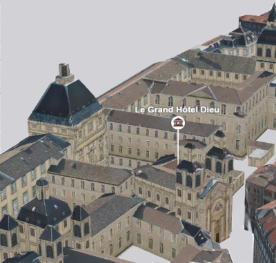
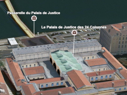
require(["esri/symbols/callouts/LineCallout3D"], function(LineCallout3D) { /* code goes here */ });esri/symbols/callouts/LineCallout3DThis type of callout displays a line to connect a symbol or a label with its actual location in the scene. For example when displaying points of interest in a city, visualizing them with a callout line helps to understand where the points are actually located:
This visualization can be created on a PointSymbol3D or a LabelSymbol3D. After defining the symbolLayers, an offset should be defined by setting the verticalOffset property. The symbols are now shifted vertically, but we still need to add the callout, otherwise it can be very confusing to understand where the points are located:
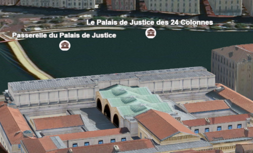
Setting the callout property of type line on the symbol will create the line that connects the symbol with its actual position:
Autocasting support
As of version 4.5 of the ArcGIS API for JavaScript, autocasting is universally supported for all renderers, symbols, and symbol layers in the API. So there is no need to include this module in the require() and define() module loaders of your application unless you intend to use the static method(s) of this module.
var symbol = {
  type: "point-3d",  // autocasts as new PointSymbol3D()
  symbolLayers: [{
    type: "icon",  // autocasts as new IconSymbol3DLayer()
    resource: {
      href: "CityHall.svg"
    },
    size: 20
  }],
  verticalOffset: {
    screenLength: 40,
    maxWorldLength: 100,
    minWorldLength: 20
  },
  callout: {
    type: "line", // autocasts as new LineCallout3D()
    size: 1.5,
    color: "white",
    border: {
      color: "black"
    }
  }
});
Constructors
- new LineCallout3D(properties)
- Parameter:properties Objectoptional
See the properties for a list of all the properties that may be passed into the constructor.
Property Overview
| Name | Type | Summary | Class | |
|---|---|---|---|---|
| Accessor | The border settings of the callout line. more details | more details | LineCallout3D | |
| Color | The color of the callout line. more details | more details | LineCallout3D | |
| String | The name of the class. more details | more details | Accessor | |
| Number | The width of the callout line in points. more details | more details | LineCallout3D | |
| String | For LineCallout3D the type is always | more details | LineCallout3D |
Property Details
- borderAccessor
The border settings of the callout line. The border of the callout line can be used to improve the contrast of the callout line color against various background colors. If the border is
null, then no border will be visible.
The color of the callout line. This can be autocast with a named string, hex string, array of rgb or rgba values, an object with
r,g,b, andaproperties, or a Color object.- Default Value:black
- Since: ArcGIS API for JavaScript 4.7
The name of the class. The declared class name is formatted as
esri.folder.className.
The width of the callout line in points. This value may be autocast with a string expressing size in points or pixels (e.g.
12px).- Default Value:1px
- typeString
For LineCallout3D the type is always
line.
Method Overview
| Name | Return Type | Summary | Class | |
|---|---|---|---|---|
| LineCallout3D | Creates a deep clone of the callout. more details | more details | LineCallout3D | |
| * | Creates a new instance of this class and initializes it with values from a JSON object generated from a product in the ArcGIS platform. more details | more details | Callout3D | |
| Object | Converts an instance of this class to its ArcGIS portal JSON representation. more details | more details | Callout3D |
Method Details
- clone(){LineCallout3D}
Creates a deep clone of the callout.
Returns:Type Description LineCallout3D A deep clone of the object that invoked this method.
- fromJSON(json){*}static
Creates a new instance of this class and initializes it with values from a JSON object generated from a product in the ArcGIS platform. The object passed into the input
jsonparameter often comes from a response to a query operation in the REST API or a toJSON() method from another ArcGIS product. See the Using fromJSON() topic in the Guide for details and examples of when and how to use this function.Parameter:json ObjectA JSON representation of the instance in the ArcGIS format. See the ArcGIS REST API documentation for examples of the structure of various input JSON objects.
Returns:Type Description * Returns a new instance of this class.
Converts an instance of this class to its ArcGIS portal JSON representation. See the Using fromJSON() topic in the Guide for more information.
Returns:Type Description Object The ArcGIS portal JSON representation of an instance of this class.