LabelSymbol3D
require(["esri/symbols/LabelSymbol3D"], function(LabelSymbol3D) { /* code goes here */ });esri/symbols/LabelSymbol3DLabelSymbol3D is used to render labels for features from a FeatureLayer in a 3D SceneView. This symbol type is not supported in 2D MapViews.
A LabelSymbol3D must include at least one symbol layer for it to render in the view. One or more of the following symbol layer types my be used to define a 3D label symbol:
| Symbol3DLayer Type | Flat/Volumetric | Size Units | Example |
|---|---|---|---|
| TextSymbol3DLayer | flat | points |  |
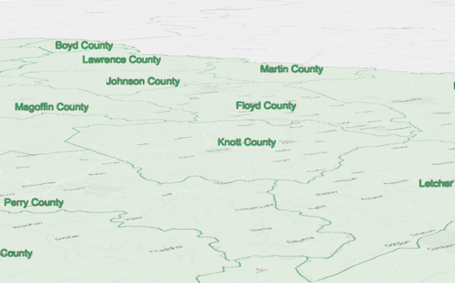
The image below depicts a FeatureLayer with labels defined by LabelSymbol3D.
Autocasting support
As of version 4.5 of the ArcGIS API for JavaScript, autocasting is universally supported for all renderers, symbols, and symbol layers in the API. So there is no need to include this module in the require() and define() module loaders of your application unless you intend to use the static method(s) of this module.
var labelClass = new LabelClass({
  labelExpressionInfo: {
    expression: "$feature.COUNTY"  // Text for labels comes from COUNTY field
  },
  symbol: {
    type: "label-3d",  // autocasts as new LabelSymbol3D()
    symbolLayers: [{
      type: "text",  // autocasts as new TextSymbol3DLayer()
      material: { color: [ 49,163,84 ] },
      size: 12  // Defined in points
    }]
  }
});
// Add labels to the feature layer
featureLayer.labelsVisible = true;
featureLayer.labelingInfo = [ labelClass ];
Constructors
- new LabelSymbol3D(properties)
- Parameter:properties Objectoptional
See the properties for a list of all the properties that may be passed into the constructor.
Property Overview
| Name | Type | Summary | Class | |
|---|---|---|---|---|
| Callout3D | Settings for adding a callout visualization to the symbol. more details | more details | LabelSymbol3D | |
| String | The name of the class. more details | more details | Accessor | |
| Collection<Symbol3DLayer> | A Collection of Symbol3DLayer objects used to visualize the graphic or feature. more details | more details | Symbol3D | |
| String | For LabelSymbol3D the type is always | more details | LabelSymbol3D | |
| Accessor | Shifts the symbol along the vertical world axis by a given height. more details | more details | LabelSymbol3D |
Property Details
- calloutCallout3DSince: ArcGIS API for JavaScript 4.4
Settings for adding a callout visualization to the symbol. Callouts are drawn from the point feature location that is being symbolized, to the vertical offset of the symbol. This property has no effect if verticalOffset is not set. At the moment only callouts of type
lineare supported. See LineCallout3D.Example:var symbol = { type: "label-3d", // autocasts as new LabelSymbol3D() symbolLayers: [...], verticalOffset: ..., callout: { type: "line", // autocasts as new LineCallout3D() size: 1.5, color: [150, 150, 150], border: { color: [50, 50, 50] } } };
- Since: ArcGIS API for JavaScript 4.7
The name of the class. The declared class name is formatted as
esri.folder.className.
- Autocasts from Object[]
A Collection of Symbol3DLayer objects used to visualize the graphic or feature. Individual symbol layers may be autocast as objects and specified using the
typeproperty.
- typeStringreadonly
For LabelSymbol3D the type is always
label-3d.
- verticalOffsetAccessorSince: ArcGIS API for JavaScript 4.4
Shifts the symbol along the vertical world axis by a given height. The height is set in screen space units like points or pixels. For points displayed with a callout
verticalOffsetshould be set.- Properties:
- screenLength Number
The vertical symbol offset in points. This value may be autocast with a string expressing size in points or pixels (e.g.
12px).optionalminWorldLength NumberThe minimum vertical symbol offset in world units. It acts as a lower bound to avoid the vertical offset becoming too small.
In the following animation the green symbol on the left has
minWorldLength = 20and for the orange symbol on the rightminWorldLengthhas not been set: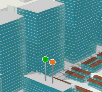 optionalmaxWorldLength Number
The maximum vertical symbol offset in world units. It acts as an upper bound to avoid vertical offset becoming too big.
In the following animation the green symbols have
maxWorldLength = 50and orange symbols don't havemaxWorldLengthset: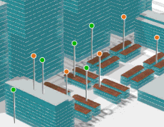
- See also:
Example:var symbol = { type: "label-3d", // autocasts as new LabelSymbol3D() symbolLayers: [...], verticalOffset: { screenLength: 40, maxWorldLength: 100, minWorldLength: 20 }, callout: ... };
Method Overview
| Name | Return Type | Summary | Class | |
|---|---|---|---|---|
| LabelSymbol3D | Creates a deep clone of the symbol. more details | more details | LabelSymbol3D | |
| * | Creates a new instance of this class and initializes it with values from a JSON object generated from a product in the ArcGIS platform. more details | more details | Symbol | |
| Object | Converts an instance of this class to its ArcGIS portal JSON representation. more details | more details | Symbol |
Method Details
- clone(){LabelSymbol3D}
Creates a deep clone of the symbol.
Returns:Type Description LabelSymbol3D A deep clone of the object that invoked this method. Example:// Creates a deep clone of the graphic's symbol var symLyr = graphic.symbol.clone();
- fromJSON(json){*}static
Creates a new instance of this class and initializes it with values from a JSON object generated from a product in the ArcGIS platform. The object passed into the input
jsonparameter often comes from a response to a query operation in the REST API or a toJSON() method from another ArcGIS product. See the Using fromJSON() topic in the Guide for details and examples of when and how to use this function.Parameter:json ObjectA JSON representation of the instance in the ArcGIS format. See the ArcGIS REST API documentation for examples of the structure of various input JSON objects.
Returns:Type Description * Returns a new instance of this class.
Converts an instance of this class to its ArcGIS portal JSON representation. See the Using fromJSON() topic in the Guide for more information.
Returns:Type Description Object The ArcGIS portal JSON representation of an instance of this class.