 Hide Table of Contents
 Tutorials
About the API
Work with the API
Graphics and feature layers
Popups and Info Windows
Geoprocessor
Operations Dashboard
Create extensions
Mobile
ArcGIS Server Services
References
What's New archive
Tutorials
About the API
Work with the API
Graphics and feature layers
Popups and Info Windows
Geoprocessor
Operations Dashboard
Create extensions
Mobile
ArcGIS Server Services
References
What's New archive
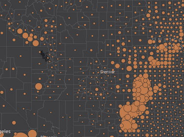
Scale driven sizing for polygon markers and outlines
Easily define renderers that calculate symbol size based on attribute values as well as map scale. Applies to polygon markers and polygon outline width.
- The
createSizeRenderermethod supports the following values for itsoptimizeForScaleparameter. For example,map-scaleortrueindicates that the size range is optimized only for the current map scale. Next,visible-scale-rangeindicates that the range is optimized for all scales in the layer's visible scale range. - Added support for
sizeInfo.stops. Each stop hasvalueandsizeproperties. - Added support for
sizeInfo.expression. - Added support for
sizeInfo.minSizeandsizeInfo.maxSizeto be an actualSizeInfoobject itself.
BlendRenderer
A new BlendRenderer class was added. BlendRenderer allows you to easily identify a predominant attribute of a feature among two or more competing attributes. For example:
- What is the most predominant pet in an area? Dogs or cats?
- What is the most predominant type of household in a neighborhood? Owner-occupied or renter-occupied?
Each attribute is assigned a unique color. The value of the color's opacity is calculated based on the value of that attribute for a given feature. Meaning the higher the attribute value, the more dominant the attribute becomes.

Layer list widget
The LayerList widget allows users to turn layers on and off. NOTE: This is currently in beta.

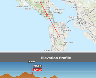
Elevation profile widget
The Elevation profile widget allows users
to view an elevation profile along a path. NOTE: This is currently in beta.
Support for OGC Web Feature Services
The Open Geospatial Consortium Web Feature Service Interface Standard (WFS) provides an interface allowing requests for geographical features across the web using platform-independent calls. For more information about the Web Feature Service, see the following Wikipedia article, and the OGC Web Feature Service home page. For more details, see the WFSLayer API Reference (beta at version 3.14) and the WFSLayer sample.
Extend Operations Dashboard
Developers and partners can write new widgets, map tools, and feature actions for Operations Dashboard using ArcGIS API for JavaScript. Administrators can add extensions to their organizations for publishers to use inside of their operation views. For more information, see Extend Operations Dashboard.
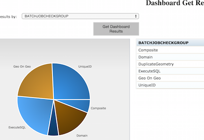
DataReviewer
A new series of tasks that work to integrate data quality control features into your application. These tasks leverage ArcGIS Data Reviewer for Server capabilities allowing you to implement:
- automated validation of data using rules authored in ArcMap
- data quality reporting that highlights issues in your data
- workflows that let you identify data errors using redlining and mark-up tools
- workflows that let you track and report errors through an iterative correction process
See the Working with DataReviewer help topic and the ArcGIS Resource Center to learn more about using ArcGIS Data Reviewer.
Directions widget changes
The 3.14 Directions widget has been migrated to use the Search widget. In order to feed a custom geocoder/feature services into this widget, use the new searchOptions property.
GeometryEngine changes
Prior to 3.14, the unit parameter in several GeometryEngine methods, such as buffer(), geodesicArea(), offset(), etc. required a number value from this list. While these numbers are still supported, all unit parameters in these methods can take string values (e.g. "miles", "meters", "square-feet", etc.) starting in version 3.14. This should make using and reading geometryEngine methods easier. See the documentation for more details.
Starting with 3.14, the input arrays for geometries and buffer values in GeometryEngine.buffer() and GeometryEngine.geodesicBuffer() do not have to be the same length. Refer to the documentation for additional details.
Image server related changes
RasterLayerclass is no longer in beta.- Two new methods added to
RasterLayer,setImageFormatandsetUseMapTime. PixelBlockclass is no longer in beta.- A new
OPERATION_SUMconstant added toMosaicRule. - A new
ImageServiceMeasureTaskclass was added. - A new
ImageServiceMeasureParametersclass was added. - A new
ImageServiceMeasureToolclass was added. - A new
ImageServiceMeasureclass was added. - A new
ImageSpatialReferenceclass was added. - A new beta
ObliqueViewerwidget was added.
New locales
- Version 3.14 adds support for Traditional Chinese (Taiwan) (language code "zh-tw"). Add the following line snippet to any code sample to see it in Traditional Chinese (Taiwan).
<script> var dojoConfig = {locale: "zh-tw"}; </script> - Version 3.14 adds support for Traditional Chinese (Hong Kong) (language code "zh-hk"). Add the following line snippet to any code sample to see it in Traditional Chinese (Hong Kong).
<script> var dojoConfig = {locale: "zh-hk"}; </script>
API enhancements
- esri/dijit
- New class
ElevationProfile(beta) - New class
ImageServiceMeasure - New class
LayerList(beta) - New class
ObliqueViewer
- New class
- New class
ImageSpatialReference - New class
ImageServiceMeasureParameters - New class
ImageServiceMeasureTask - New class
BlendRenderer - New class
ImageServiceMeasureTool - esri/opsdashboard
- New class
DataSourceProxy - New class
ExtensionBase - New class
ExtensionConfigurationBase - New class
FeatureActionConfigurationProxy - New class
FeatureActionFeatures - New class
featureActionProxy - New class
GraphicsLayerProxy - New class
MapToolConfigurationProxy - New class
MapToolProxy - New class
MapWidgetProxy - New class
WidgetConfigurationProxy - New class
WidgetProxy
- New class
- New class
WFSLayer(beta) - esri/tasks/datareviewer
- New class
BatchValidationJob - New class
BatchValidationJobInfo - New class
BatchValidationParameters - New class
BatchValidationTask - New class
DashboardResult - New class
DashboardTask - New class
GetResultsQueryParameters - New class
ReviewerAttributes - New class
ReviewerFilters - New class
ReviewerLifecycle - New class
ReviewerResultsTask - New class
ReviewerSession - New class
SessionOptions
- New class
- New constant
OPERATION_SUMon class MosaicRule - New constants
DEFAULT_CURVE_EXTENSION,KEEP_END_ATTRIBUTES,NO_END_ATTRIBUTES,NO_EXTEND_AT_FROM,NO_EXTEND_AT_TO,RELOCATE_ENDSon class TrimExtendParameters - New properties
showCloseIcon,showSelectAnalysisLayeron classAggregatePoints - New properties
showCloseIcon,showSelectAnalysisLayeron classCalculateDensity - New properties
showCloseIcon,showSelectAnalysisLayeron classConnectOriginsToDestinations - New properties
showCloseIcon,showSelectAnalysisLayeron classCreateBuffers - New properties
showCloseIcon,showSelectAnalysisLayeron classCreateDriveTimeAreas - New properties
showCloseIcon,showSelectAnalysisLayeron classCreateViewshed - New properties
showCloseIcon,showSelectAnalysisLayeron classCreateWatersheds - New properties
showCloseIcon,showSelectAnalysisLayeron classDeriveNewLocations - New properties
showCloseIcon,showSelectAnalysisLayeron classDissolveBoundaries - New properties
showCloseIcon,showSelectAnalysisLayeron classEnrichLayer - New properties
showCloseIcon,showSelectAnalysisLayeron classExtractData - New properties
showCloseIcon,showSelectAnalysisLayeron classFindExistingLocations - New properties
showCloseIcon,showSelectAnalysisLayeron classFindHotSpots - New properties
showCloseIcon,showSelectAnalysisLayeron classFindNearest - New properties
showCloseIcon,showSelectAnalysisLayeron classFindSimilarLocations - New properties
showCloseIcon,showSelectAnalysisLayeron classInterpolatePoints - New properties
showCloseIcon,showSelectAnalysisLayeron classMergeLayers - New properties
showCloseIcon,showSelectAnalysisLayeron classOverlayLayers - New properties
showCloseIcon,showSelectAnalysisLayeron classPlanRoutes - New properties
showCloseIcon,showSelectAnalysisLayeron classSummarizeNearby - New properties
showCloseIcon,showSelectAnalysisLayeron classSummarizeWithin - New properties
showCloseIcon,showSelectAnalysisLayeron classTraceDownstream - New property
editToolbaron classEditor - New property
overviewMapon classOverviewMap - New property
travelModeon classClosestFacilityParameters - New property
showLabelson classPrintTemplate - New property
travelModeon classRouteParameters - New property
travelModeon classServiceAreaParameters - New methods
setImageFormat(),setUseMapTime()on classRasterLayer - New method
getLatestObservations()on classStreamLayer - New method
getServiceDescription()on classClosestFacilityTask - New method
getServiceDescription()on classRouteTask - New method
getServiceDescription()on classServiceAreaTask Editorwidget has a publiceditToolbarproperty, providing access to the widget'sEdittoolbar.
New samples
- BlendRenderer
- Smartmapping
- DataReviewer
- Elevation profile widget
- Layer list widget
- Search widget
- WFS layer
Bug fixes
Many of the bugs fixed in this release improve support for touch events in IE10/IE11. See the list below for a detailed look at these bug fixes.- BUG-000086204: Fixed an IE10 and IE11 issue when editing vertices and snapping to line/polygon features didn't work correctly.
- BUG-000085838: Fixed an issue where polar projection coordinates displayed incorrectly when using the measurement widget.
- NIM094815: The mouse-drag event now works correctly using IE10 and IE11.
- NIM101882/BUG-000085005: Draw tools now creates the starting vertex point at the correct position using IE10 and IE11.
- BUG-000083753: Using IE10 or IE11, there is no longer an additional vertex added when creating a polyline or polygon.
- BUG-000086260: Fixed an issue where if two or more KML layers overlapped one another, the layers did not display correctly.
- BUG-000085097: Fixed an issue where searching for features would fail if the service used did not support pagination.
- NIM102402: Fixed an issue where if using a map image layer, it would change position when panning using specific mouse buttons.
- BUG-000087742: Fixed an issue where fields with coded value domains showed "required" even if the field was nullable.
- BUG-000087358: Fixed an issue where using cacheBust:true rendered SimpleFillSymbol incorrectly.
- BUG-000087174: Fixed an issue where it was not possible to create multiple KML layers.
- BUG-000087251: It is now possible to add and edit features using the Editor toolbar if the map contains a WMTS layer.
- BUG-000086146: Fixed an IE11 issue where tiles would not load while panning unless mouse button is released.
- BUG-000086150: Fixed an an issue specific to 3.13 where legends would fail if using JSON data.
- BUG-000085436: Fixed an issue where polyline vertexes were showing multiple endpoints when using IE11.
- BUG-000084867: Fixed an issue where using the Esc key would result in an "uncaught type error" while aborting a sketch.
- BUG-000084429: Fixed an issue where if using Chrome, the mouse would remain in Pan mode.
- BUG-000086624: Fixed an issue where clicking the edge of the map causes the InfoWindow to be displayed.
- BUG-000087378: Fixed an issue where a feature's geometry display was affected in the map viewer if the query request uses the quantization parameter.
- ENH-000084434: A default symbol value is now used in renderers if the normalization field value is zero.
- Editing:
- BUG-000086767: Fixed an issue where editing always applied attributes from the first edited feature on subsequent edits.
- NIM102567: Editors can now add attachments to hosted feature services.
- Map resizing:
- NIM099625: Fixed an issue where hidden maps became corrupt after map auto-resize.
- NIM091498: Fixed an issue where map disappeared when the view and orientation of iPad/iPhone and Android was changed.
- BUG-000087082: Fixed an issue where map with vertical scroll bar drew at a wrong position using 'Draw' toolbar when map is scrolled.
- Documentation:
- BUG-000086784: Corrected API documentation to state that add() is not supported with FeatureLayer or LabelLayer classes.
- BUG-000087582: Fixed BasemapToggle documentation to reflect the correct object property names for basemaps property.
- BUG-000086608: Fixed broken sample to now work as described.
Web Optimizer changes and enhancements
- Now includes options for put-selector, and xstyle packages in the user-interface.
- Provide user feedback when logging in with an invalid account such as a public account. See prerequisites
- Updates to support locales Thai (th), Turkish (tr), Traditional Chinese (Taiwan) (zh-tw), Traditional Chinese (Hong Kong) (zh-hk).
Additional Resources on GitHub
Be certain to check out any updates to the repository on GitHub with TypeScript definitions for the JS API as well as the jshint options file used by the JS API team.
Additional packages
Version 3.14 of the ArcGIS API for JavaScript includes Dojo 1.10.4, dgrid version 0.3.17, dstore version 1.1.0, put-selector version 0.3.6 and xstyle version 0.1.3. The dstore package inclusion is new for 3.14.